
Japan Earthquake Maps Show the Latest Damage and Areas Affected by the Powerful Quake

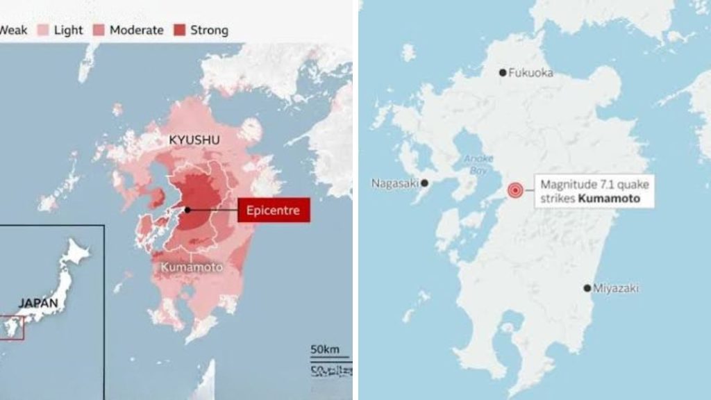
Japan earthquake maps are providing a clearer picture of the destruction caused by the powerful quake that struck Kumamoto Prefecture on July 28, 2026. The earthquake shook a wide section of Kyushu, damaging homes, roads, factories, transport networks and historic buildings. The latest maps place the centre of the strongest shaking south of Kumamoto City, with Kashima, Uki, Uto and Yatsushiro among the most seriously affected areas. Search teams continued working through damaged structures on July 29 as officials assessed the full scale of the disaster.
 Extreme Weather Across North America Brings Alaska Snow Wisconsin Tornado and Hurricane Genevieve
Japan Earthquake Damage Map Highlights the Hardest-Hit Zone
The Japan earthquake damage map shows that the quake originated in the Kumamoto region at 4:27 p.m. local time. The Japan Meteorological Agency measured the event at magnitude 7.1 and placed it at a shallow depth of approximately 10 kilometres. Its recorded coordinates were 32.6 degrees north and 130.7 degrees east. The US Geological Survey reported a slightly lower magnitude of 6.8 and located the centre about five kilometres east of Uto. Differences between agency readings are common because they may use separate measurement methods and seismic data.

Kashima and Yatsushiro Report Severe Damage
Maps and aerial reports identify Kashima Town as one of the main emergency zones. Part of the Aeon Mall collapsed after an apparent explosion following the earthquake. Rescue workers, police officers and Self-Defense Force personnel searched the damaged building for people who remained missing.
Farther south, Yatsushiro also suffered extensive structural damage. Several houses collapsed or lost sections of their roofs, while roads cracked and buckled. A chimney at a Nippon Paper Industries factory fell, trapping workers beneath debris. Part of a bridge also collapsed into the Kumagawa River, creating further transport difficulties in the area.

Damage Extends Across Central Kyushu
Although the most severe destruction was concentrated in Kumamoto Prefecture, shaking was recorded across a broader section of Kyushu. Kumamoto City, located about 20 kilometres north of the epicentre, reported damage to buildings and public landmarks. Stone walls at Kumamoto Castle were damaged again while restoration work from the 2016 earthquakes was still underway.
The quake also affected shrines, traditional buildings and businesses with heavy tiled roofs. Fires and partial building collapses were reported in several communities. These reports suggest that older structures and areas close to the shallow epicentre faced the greatest risk.
Power, Roads and Transport Services Disrupted
The affected-area maps also show why travel across central Kyushu became difficult. Major roads developed deep cracks, while damaged bridges forced drivers to use alternative routes. Kyushu Shinkansen bullet train services were suspended, and operations at Aso Kumamoto Airport were disrupted.
More than 36,000 homes remained without electricity on July 29, while around 9,500 households had no gas service. Communication networks were unavailable in some locations. Several technology and manufacturing companies temporarily stopped production or evacuated employees while engineers inspected their facilities.
Rescue Operations Continue as Aftershock Risk Remains
At least 13 people had been confirmed dead by July 29, although officials warned that the figure could change as searches continued. More than 9,000 residents moved into hundreds of shelters, where additional power supplies were being installed to provide air conditioning during the extreme summer heat.
Authorities advised people in damaged areas to avoid unstable buildings, broken roads and steep slopes. Strong aftershocks and earthquake-triggered landslides remain possible for about a week. Residents are being encouraged to follow official maps and local evacuation instructions rather than relying on unverified images circulating online.
Sources
- Japan Meteorological Agency — Recorded the Kumamoto earthquake at magnitude 7.1, a depth of 10 kilometres and coordinates of 32.6°N, 130.7°E.
- US Geological Survey — Measured the earthquake at magnitude 6.8 and located it around five kilometres east of Uto.
- Reuters — Reported severe damage in Yatsushiro, cracked roads, a collapsed bridge and widespread factory shutdowns.
- Associated Press — Reported at least 13 deaths, thousands of displaced residents and major damage to the Aeon Mall and Kumamoto Castle.
- Financial Times — Reported collapsed buildings, power outages, suspended transport and disruption at major industrial facilities across Kumamoto.
