
Hartford Flash Flood Warning Remains in Effect as Heavy Rain Threatens More Flooding

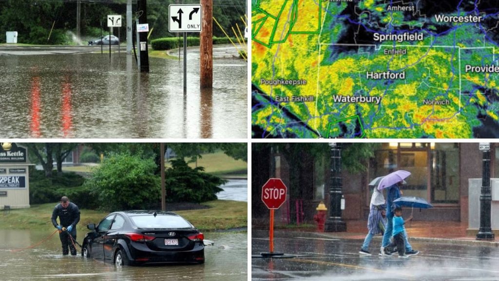
Steady rain kept conditions hazardous in Hartford and elsewhere in Connecticut Wednesday, July 29, with slow-moving downpours taxing drainage systems and increasing the threat of flash floods. The storm struck amid an exceptionally rainy stretch in the North-east, leaving roads, streams and low-lying communities particularly susceptible. Officials warned residents to stay tuned to local notifications, as water levels could increase swiftly in areas where the most intense bands of rain remained.

Flash Flood Warning Hartford
The Hartford flash flood warning, which covers Hartford County and downtown Hartford, was set to expire at 5:30 p.m. EDT Wednesday. Forecasters cautioned that heavy rain might cause flooding in city streets, underpasses, tiny streams and poorly drained areas. A larger flood watch was also in effect for Hartford and Tolland counties until 8 p.m., meaning more flooding was possible after any particular warnings expire.

Heavy Rain Keeps Flood Threat Elevated
The storm system progressed slowly, with multiple rounds of showers and thunderstorms passing over some of the same locations. This pattern, called training, can deliver large amounts of rain over a short period of time. Forecasters in the area said more than four inches of storm-total rain fell at Bradley International Airport, which is where the official meteorological records are kept for the Hartford area. Some of the heavy downpours might produce one to two inches of rain in an hour, which could quickly overwhelm drainage systems.

Local Area Roads Closed
Flooding and storm damage made travel difficult in some Connecticut cities. Closed roads were reported in East Windsor and Avon, and other areas were battling standing water, fallen trees and broken cables. Low-lying roads and areas under bridges where water can build up more quickly than drivers think were particularly perilous. Flight delays and cancellations were also reported throughout the North-east, especially at airports servicing Hartford, New York and Boston.
 Extreme Weather Across North America Brings Alaska Snow Wisconsin Tornado and Hurricane Genevieve
How Flash Floods Can Develop Rapidly
When heavy rain falls on saturated ground or on paved urban surfaces , flash floods can occur with little notice . Water runs into streams and drainage systems instead of soaking into the soil and levels rise quickly. Heavy rainfalls can cause added strain on Hartford’s built-up streets, underpasses and densely inhabited regions. Even when the rain may stop for a bit, runoff from surrounding communities can still flow to lower places.
Safety Advice for Residents and Drivers
People in impacted areas should avoid flooded roadways and never drive through road barricades. The National Weather Service urges vehicles to turn around instead of driving into water covering a road. Depth can be difficult to assess and the pavement underneath may be damaged or totally washed away.
Officials may issue urgent instructions, so people who live in basements or in homes that are prone to flooding should keep their phones charged, secure necessary medicines and important documents and be ready to transfer to higher ground. “Anyone needing mobility, language or medical assistance should arrange support early and not wait for conditions to become more dangerous.
More showers still possible
The hardest rain was beginning to let up in some areas of Connecticut, but the broader weather pattern remained unpredictable. Showers and thunderstorms were still predicted through Thursday, with locally heavy rain that could possibly produce isolated floods. As the storm moves away, conditions were forecast to progressively improve, although wet roads, fog and lingering high water could continue to impede travel after the rainfall finished.
Sources
- National Weather Service — Forecasters identified urban areas, poor-drainage locations and the Hartford region as particularly vulnerable to dangerous flash flooding.
- NBC Connecticut — Hartford County, including downtown Hartford, was placed under a flash flood warning until 5:30 p.m. EDT Wednesday.
- WFSB — Bradley International Airport recorded more than four inches of storm-total rainfall during the event.
- CT Insider — Flooding, downed trees and wires contributed to road closures in communities including East Windsor and Avon.
- Times Union — The same storm produced extreme rainfall, flash flooding, road closures and emergency rescues across neighbouring parts of New York.
