
El Niño 2026 Continues to Strengthen as Experts Predict Big Changes for California Rainfall

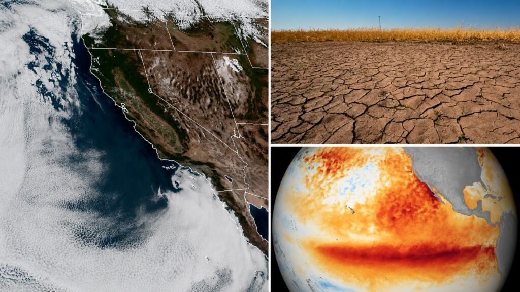
El Niño 2026 is strengthening across the tropical Pacific, and the latest federal forecast has sharply raised the possibility of an unusually powerful event. NOAA’s Climate Prediction Center said on July 9 that there is an 81% chance of a very strong El Niño during October–December 2026, while the event has a 97% chance of continuing through early spring 2027. For California, that raises the odds of a wetter winter—but it does not guarantee one.

How Strong Is El Niño 2026 Becoming?
The latest ocean measurements show why confidence has increased. NOAA reported that sea-surface temperature anomalies exceeded 1°C across a broad section of the central and eastern equatorial Pacific.
The weekly Niño-3.4 index stood at +1.2°C, while the Niño-1+2 region in the eastern Pacific had reached +2.7°C. Ocean and atmospheric conditions were acting together in a pattern consistent with a strengthening El Niño.
 Flash Flood Warning Issued for NYC and Long Island as Severe Storms Bring Heavy Rain and Flood Risks
The World Meteorological Organization has also described the development as rapid. Its latest seasonal assessment projects strong El Niño conditions during July–September, with average sea-surface temperature anomalies expected to exceed 2°C in important monitoring regions.
Could El Niño 2026 Bring More Rain to California?
Historically, moderate and strong El Niño events can shift the winter storm track in ways that favour above-normal precipitation across parts of the southern United States, including Southern California. The influence is generally much stronger from late fall through spring than during summer.
Greater El Niño strength can tilt the odds toward expected rainfall patterns, but it cannot determine the exact rainfall total for an individual city, watershed or mountain range months in advance.
Which Parts of California Could See the Biggest Changes?
A wetter El Niño pattern could increase the potential for more winter storms, additional Sierra Nevada snowfall and improved water supply conditions in some areas. However, repeated periods of heavy rain can also increase the risk of flooding, erosion and other storm-related disruption.
California-focused forecasts generally show a stronger historical wet-weather signal for Southern California during powerful El Niño winters. Northern and Central California outcomes can be more variable, and the exact location of Pacific storm tracks will play a major role.
Does a Very Strong El Niño Guarantee a Wet Winter?
The famously wet 1997–98 winter remains part of California’s weather memory. However, the very strong 2015–16 El Niño did not produce the level of Southern California precipitation that many people had expected.
A very strong El Niño can increase the probability of certain weather patterns, but other atmospheric and ocean conditions still influence the final outcome.
When Will California Get a Clearer Rainfall Forecast?
A stronger El Niño generally increases the likelihood of wetter winter conditions across the southern United States and warmer winter conditions farther north. Experts have emphasised, however, that a powerful ocean signal increases the chances of certain weather outcomes rather than guaranteeing extreme weather in every region.
Sources
- NOAA Climate Prediction Center — Used for the July 9, 2026 ENSO update, the 81% very-strong-event probability, the 97% persistence probability and Pacific temperature measurements.
- World Meteorological Organization — Used for the rapid-strengthening outlook, projected temperature anomalies and context explaining why regional effects vary between El Niño events.
- Associated Press — Used for expert context on expected fall and winter impacts and the distinction between stronger El Niño conditions and guaranteed extreme local weather.
- SFGATE — Used for California-specific rainfall, Sierra snowpack and impact uncertainty context, including comparisons with previous strong events.
- National Weather Service — Used for background on the historical relationship between moderate-to-strong El Niño events and wetter winter conditions in Southern California.
