
Typhoon Bavi 2026 Hits Guam and Northern Mariana Islands With Dangerous Winds and Rain

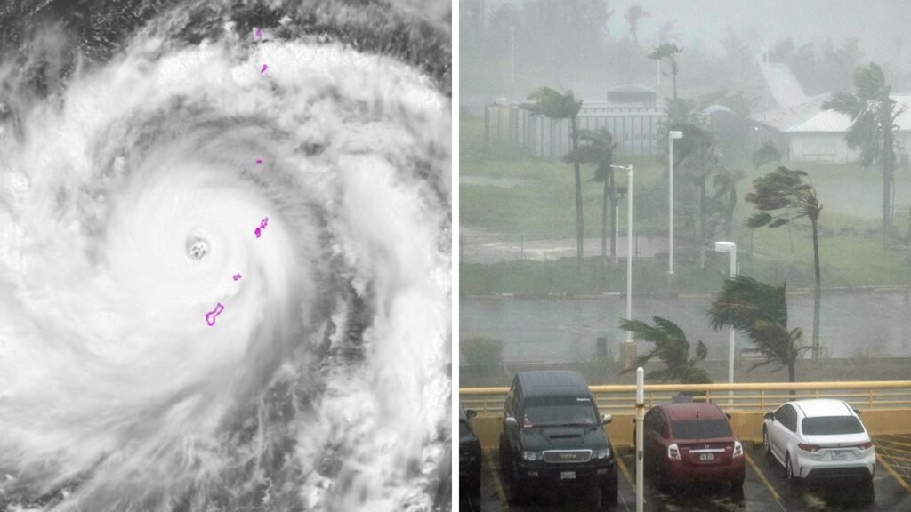
Typhoon Bavi 2026 has battered Guam and the Northern Mariana Islands with destructive winds, intense rain and dangerous coastal conditions, leaving Rota at the center of the storm’s worst impacts. The Category 5 system crossed the Mariana chain on July 6, with the National Weather Service warning of catastrophic conditions as Bavi’s eyewall moved across Rota.

Rota Faces the Worst of Typhoon Bavi’s Winds
The storm’s most extreme winds were focused on Rota, the southernmost major island in the Northern Mariana Islands. Reuters reported sustained winds of up to 180 mph, or 290 kph, with possible gusts reaching 215 mph as the eyewall came ashore. Local authorities later reported major damage on the island, while Guam, Tinian and Saipan also experienced damaging winds, heavy rain and widespread disruption. The full scale of damage on Rota is still being assessed, but the combination of extreme winds and heavy rainfall has created major recovery challenges for the island.

Heavy Rain Raises Flooding Risk Across the Islands
Forecasts called for 12 to 20 inches, or 30 to 51 cm, of rain near the storm’s center. Such intense rainfall can quickly trigger flash flooding, especially in low-lying and poorly drained areas.

Ahead of the storm, Guam opened evacuation centers and residents were urged to remain indoors as dangerous winds and rainfall moved through the region.
 Washington DC Extreme Heat Wave Forces Independence Day Parade to Be Canceled Across the Capital
Heavy rain also made travel more dangerous and increased the risk of blocked roads, damaged infrastructure and delays in emergency response operations.
Typhoon Bavi Moves Away but Remains Powerful
At 7 a.m. local time, the National Weather Service placed the center of Bavi about 300 miles northwest of Guam.
The storm was still producing sustained winds of 160 mph while moving west-northwest at around 16 mph.
As conditions began to improve, the typhoon warning for Guam, Rota, Tinian and Saipan was canceled. This allowed authorities to begin shifting their focus from emergency preparation to cleanup, damage assessment and recovery.
Guam Begins Transition Toward Recovery
The Guam Homeland Security and Office of Civil Defense announced that the island would move to Condition of Readiness 4 at 10 a.m. on July 7 following an initial assessment.
The move marked an important step toward more normal operations, although officials continued to warn residents about remaining hazards.
Even after the strongest winds had passed, fallen debris, damaged infrastructure, rough seas and localized flooding could still create risks.
Dangerous Waves and Coastal Conditions Continue
The National Weather Service warned of breaking waves of up to 20 feet around Guam, Rota, Tinian and Saipan.
Coastal inundation of 1 to 3 feet was also possible in exposed locations, while hazardous seas of 14 to 18 feet were expected to continue.
These conditions meant beaches, reefs and small-craft routes could remain dangerous even after the storm center moved farther away.
Northern Mariana Islands Face Another Difficult Recovery
Before Bavi arrived, reports indicated that power had not yet been fully restored in some areas of the Northern Mariana Islands. Some residents were also still living in temporary shelters or tents after their homes were damaged or destroyed.
The arrival of another major storm could make recovery slower and more difficult, particularly for communities already dealing with damaged homes and disrupted essential services.
Sources
-
- National Weather Service, Tiyan, Guam — Used for Bavi’s July 7 position, sustained wind speed, storm movement, canceled typhoon warnings and continuing coastal and marine hazards.
- Reuters — Used for the Category 5 storm impact, wind and gust estimates, rainfall forecasts, affected islands and Guam evacuation preparations.
- Guam Homeland Security / Office of Civil Defense — Used for information about Guam’s July 7 transition to Condition of Readiness 4 following an initial assessment.
- Associated Press — Used for background on the Northern Mariana Islands’ incomplete recovery from Super Typhoon Sinlaku, including power problems and displaced residents.
