
Hurricane Center Watching New Area in the Gulf

What is going on in the Bay of Campeche?
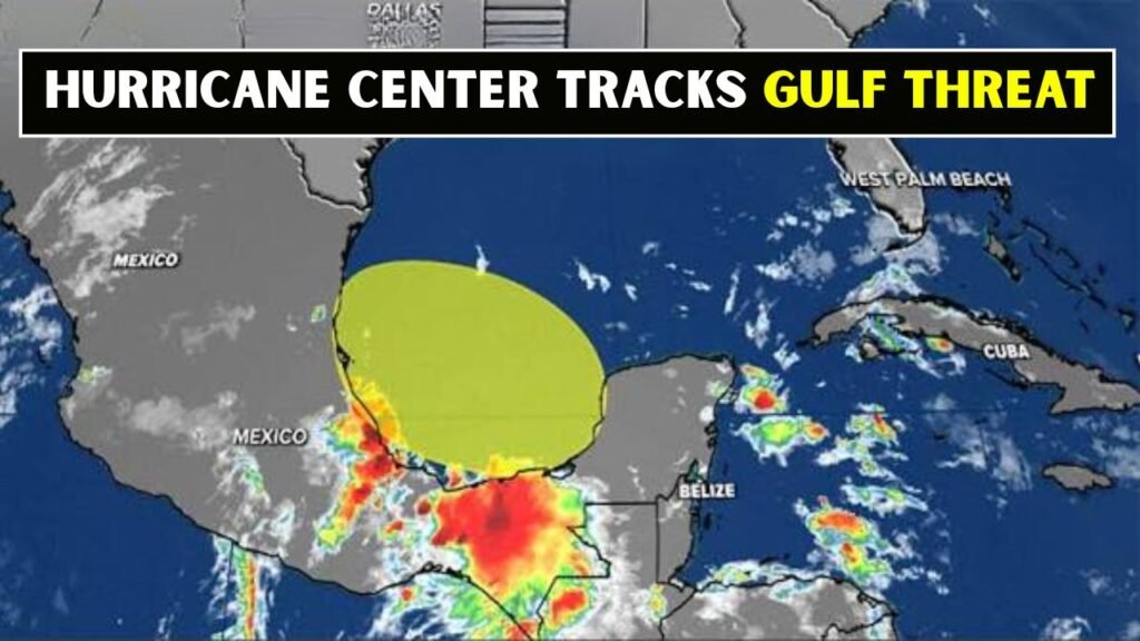
A tropical wave near the Yucatan Peninsula could assist in the development of a broad area of low pressure over the Bay of Campeche. At times, this type of setup can organise itself if the winds, moisture and sea temperatures become conducive. Conditions seem only marginally favourable now, so no rapid strengthening is expected.
 Hurricane Fausto Peaks in Pacific as Tropical Storm Genevieve Strengthens Toward Major Storm
- A tropical wave is moving west.
- Low pressure could develop over warm Gulf waters.
- The system is still broad and haphazard.
- Chances for development are low at the moment.
- The place to watch is Mexico.
Will This Gulf System Become a Tropical Storm?
There’s a low chance of this disturbance developing into a tropical depression or storm. Forecast guidance suggests the system may have little time over water to organise before it moves inland. Tropical waves can bring heavy rain, gusty winds and rough coastal conditions even if development chances are low.

Where could the unrest spread next?
The disturbance is forecast to move generally westward towards eastern Mexico late this weekend. The system isn’t well organised, and exact movement can still shift. But the current setup doesn’t indicate a big threat to the northern Gulf Coast at this time.
 Tropical Storm Genevieve Forms in the Pacific as Hurricane Fausto Strengthens to Category 2
- The likely path is into eastern Mexico.
- Generally, movement should keep going west.
- Organisation can be limited by land interaction.
- Updates should be monitored for the northern Gulf.
Possible Weather Impacts?
Usually, the biggest concern from this type of Gulf disturbance is rainfall, not wind strength. Areas near the Bay of Campeche and eastern Mexico could see periods of showers, thunderstorms and locally heavy rain. Coastal waters may also become choppy, especially near stronger clusters of thunderstorms.
Why the close watch on the Gulf?
The Gulf is being closely watched as warm water, tropical moisture and nearby land boundaries can quickly affect storm development. Early-season systems are often messy and slow to organise but still have the potential to create flooding problems. That’s why forecasters pay attention even to low-risk areas.
- Gulf waters can get warm enough to feed thunderstorms.
- Tropical waves often move across this region.
- Small changes can influence chances of development.
- Heavy rain can occur without a named storm.
Coastal Residents Are You Worrying?
Residents should be on alert but not alarmed. A low development chance doesn’t mean a dangerous storm is expected; it just means the system is being watched. This should be a reminder to folks along the Gulf Coast to check their supplies, check forecasts and follow official alerts.
What should people be watching now?
The official tropical outlooks, local weather offices and emergency managers will have the most important updates. Forecasts could change if the system becomes better organised or stays over water longer than expected. In the meantime, residents should pay attention to rain and flooding and marine conditions.
- See the latest National Hurricane Centre outlook.
- Check the local weather for heavy rain warnings.
- Do not use unofficial storm maps.
- Check your hurricane supply kit.
- Watch for changes over the weekend.
So what’s the bottom line here today?
The Hurricane Centre is watching a new disturbance in the Gulf area, but the system has a low chance of developing into a tropical system. The Bay of Campeche and eastern Mexico are the immediate concern. Even without a tropical system, tropical moisture could still mean rain and unsettled weather.