
Hurricane Fausto Moves Closer to Hawaii as Forecasters Warn of Changing Conditions

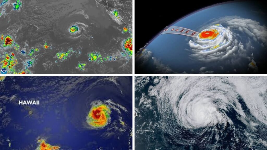
Hurricane Fausto is moving closer to Hawaii, but the latest forecast presents a mixed picture for residents and visitors. The storm remains a Category 1 hurricane over the Central Pacific, while forecasters expect it to weaken as it approaches the region. Even without a direct landfall, Fausto could create hazardous ocean conditions, shifting winds and periods of unsettled weather around the islands.
Hurricane Fausto Hawaii Forecast
The Hurricane Fausto Hawaii forecast placed the storm about 740 miles east of Hilo at 5 p.m. HST on Sunday, July 26. Maximum sustained winds were near 85 mph, and Fausto was moving west at approximately 15 mph. No coastal watches or warnings were in effect, although officials asked people throughout the Hawaiian Islands to continue monitoring updates.

Storm Track Favors a Path North of the Islands
Forecast confidence has increased that Fausto’s center and strongest weather will pass north of the main Hawaiian Islands. This path would reduce the possibility of widespread damaging winds or the heaviest rainfall reaching populated communities. However, even a small southward change could increase the risk for parts of the state.
 Hurricane Fausto Peaks in Pacific as Tropical Storm Genevieve Strengthens Toward Major Storm
Fausto is expected to weaken into a tropical storm as it continues west. Dry air, slightly cooler ocean water and stronger wind shear are forecast to disrupt its structure. The storm’s circulation remains broad, with tropical-storm-force winds extending as far as 150 miles from the center. Communities should therefore avoid focusing only on the forecast track line.

Dangerous Surf Builds Along East-Facing Shores
The most immediate concern for Hawaii is the ocean. Long-period swells generated by Fausto have begun reaching exposed east-facing shores. The National Weather Service said the incoming energy could produce warning-level surf from Monday night through early Wednesday.
Large waves may create strong rip currents, beach erosion and dangerous conditions near coastal rocks, harbors and low-lying roads. Swimmers, surfers, boaters and shoreline visitors should follow lifeguard instructions and local advisories. People with limited swimming experience should remain away from rough water, even when skies appear calm.
Marine conditions are also expected to become more challenging. Moderate to large east swells could peak between Monday night and Tuesday. Fresh trade winds are forecast to shift toward the north-northeast and gradually weaken as Fausto passes north of the state.
Wind and Rainfall Risks Continue to Change
The current track keeps Fausto’s strongest winds and deepest tropical moisture north of Hawaii. However, the storm may temporarily change the normal trade-wind pattern. Winds could weaken during the middle of the week before becoming stronger again after Fausto moves west-northwest and away from the islands.
Rainfall remains less certain. Some communities may receive passing showers, while others could experience limited tropical moisture. Mountain slopes and windward areas often record different rainfall totals, making island-specific forecasts more useful than broad statewide predictions.
Hawaii Residents Urged to Stay Prepared
Emergency officials recommend reviewing basic supplies, charging mobile devices and checking plans for family members, older adults, children, people with disabilities and pets. Visitors should confirm scheduled activities and stay away from beaches, trails or coastal roads that local authorities have closed.
Fausto’s forecast has become more favorable for Hawaii, but conditions along exposed coastlines may still be dangerous. Updates from the Central Pacific Hurricane Center and the National Weather Service will provide the clearest guidance as the storm approaches and begins passing north of the islands.
Sources
- NOAA National Hurricane Center — Fausto was 740 miles east of Hilo with 85 mph winds and no coastal watches or warnings at 5 p.m. HST Sunday.
- National Weather Service Honolulu — Fausto-related surf could reach High Surf Warning levels from Monday night through early Wednesday.
- AP News — Fausto had weakened to Category 1 and was expected to become a tropical storm while still producing significant surf in Hawaii.
- Maui Now — Forecasters expected Fausto’s strongest winds and heaviest rainfall to remain north of the Hawaiian Islands.
- Hawaii News Now — A slight southward track change could increase Hawaii’s wind and rainfall risks despite the current northward forecast.
