
Louisiana Faces Dangerous Flash Flooding as Storm Threat Grows

What is behind the flood threat?
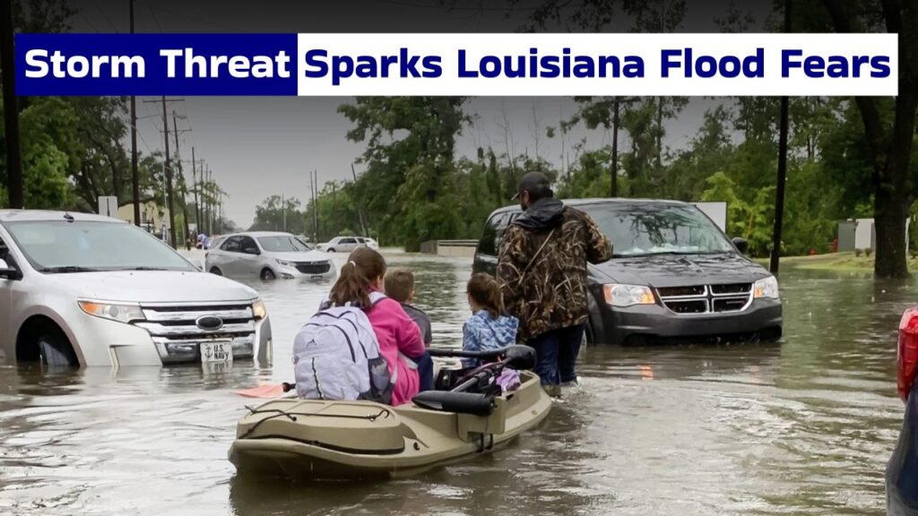
The developing Gulf system is Potential Tropical Cyclone One, and it is expected to bring very heavy rainfall into Louisiana and nearby states, which will drive the flood threat. Deep moisture, warm Gulf waters and slow-moving storms are combining in a setup that will allow rain bands to repeatedly pass over the same areas.
- Tropical moisture is sweeping across the Gulf Coast.
- Heavy rain bands moving slowly can cause flash flooding.
- Poor drainage leads to flooding in urban areas.
- Increased risk for coastal zones and low-lying roads.
How Much Rain Can Fall?
Rainfall totals could be significant across Louisiana, especially southern and central areas. Some areas will have several inches of rain in a short period of time, with isolated areas seeing much higher amounts. That increases the risk of flash floods, urban flooding and higher water in the creeks, rivers and bayous.

What areas are more vulnerable?
The greatest threat is coastal Louisiana, south-west Louisiana, south-central Louisiana and areas near major drainage channels. Cities and towns near the Texas border to central and southern Louisiana should watch weather updates closely. Inland flooding can also occur from organised, slow-moving bands of heavy rain.
 Hurricane Fausto Peaks in Pacific as Tropical Storm Genevieve Strengthens Toward Major Storm
- Heavy rain may again be a problem in southwest Louisiana.
- Coastal parishes could see flooding and high water.
- Downpours can make urban streets dangerous.
- Rural low water crossings can flood with little warning.
- Monitor water levels in river and bayou areas.
Why Flash Flooding Is So Deadly
Flash floods are deadly because they can happen in minutes and usually before people even know how bad the situation is. Fast-rising water can flood roads, underpasses, parking lots and even neighbourhoods. Even moving water, as shallow as it may be, can wash away cars, damage homes and make travel hazardous.
So what should residents do now?
Louisiana residents need to brace themselves before things get worse. “People should charge their phones, have emergency alerts on, know their local evacuation routes and avoid unnecessary travel during heavy rain.” People living in areas likely to be flooded should take important documents, medicines and valuables to safer higher ground.
- Watch for local weather advisories.
- Never drive through flooded streets.
- Pack an emergency kit with the essentials.
- Keep flashlights, batteries and chargers close at hand.
- Follow the instructions of local officials.
Can roads become dangerous fast?
Tropical downpours can suddenly make roads dangerous. Heavy rain can cut down visibility, cover up lane markings and hide washed-out pavement. Floodwater can be deeper than it looks – particularly at underpasses and low crossings. Drivers should turn around rather than attempting to cross flooded roads.
How long might the threat last?
The threat of flooding will continue through Thursday and will possibly linger in some areas if widespread rain continues to fall. Rivers, canals and drains can still rise, even after the heaviest rain has stopped. “Even if this storm weakens or moves on, the impacts of flooding can persist long after the storm has passed.”
- Flooding could continue after the rain stops.
- Drainage systems can become overloaded.
- River levels can crest later than you expect.
- Additional storms could worsen the flooding.
What’s the key safety message?
The key safety message is simple: take flash flooding seriously and take action early. “Louisiana residents should not wait for the water to rise to prepare. Stay informed with reliable weather updates, do not drive through flooded roads and go to higher ground if your area is placed under warning.”
